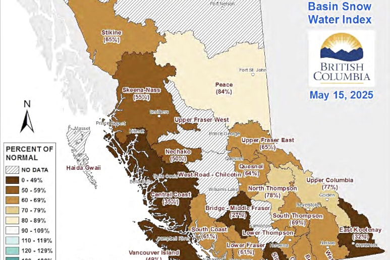
Now that freshet season is here, the province is issuing two “Snow Conditions and Water Supply” bulletins per month, and the most recent — published on May 22, with data as of May 15 — shows that the provincial snowpack was sitting at 61 per cent of normal.
This is down from the 71 per cent of normal as of May 1. The report notes that there was insufficient data to produce a snow basin index for either the Lower Thompson or Chilcotin regions.
The report also notes that while in an average year approximately 19 per cent of the seasonal snowpack has melted by May 15, as of May 15 this year 36 per cent of the peak snowpack had melted, driven primarily by warmer than normal temperatures in April.
The low snowpack means that a below normal spring freshet hazard is expected, although extreme rainfall could lead to local flooding. However, the low snowpack, early snowmelt, and warm seasonal weather forecasts — combined with the persistence of drought impacts from previous years — are pointing towards elevated drought hazards this spring and summer.
The only areas with anything near a normal snowpack for May 15 were the Peace region (84 per cent of normal) and the North Thompson region (78 per cent of normal). The Bridge region near Lillooet had the lowest snow basin index, at just 27 per cent of normal.
The average of all snow measurements for the entire Fraser River basin (upstream of the Lower Mainland and inclusive of Upper Fraser West, Upper Fraser East, Nechako, Middle Fraser, Lower Fraser, North Thompson, and South Thompson) was at 63 per cent of normal, down from 72 per cent on May 1.
Forecasts from Environment and Climate Change Canada indicate a greater likelihood of above normal temperatures in B.C. from May through July. While May is forecast to be wetter than normal in parts of northern B.C., there is a drier than normal trend for southern sections of the province, which is forecast to linger into the summer.
Weather during freshet season plays a key role in seasonal flooding, and the report notes that May and June are usually wet months in the B.C. Interior, with the potential for extreme precipitation patterns.
The next bulletin from the River Forecast Centre will contain data up to June 1, and will be released on or around June 9.

