Provincial snowpack levels were sitting at 72 per cent of normal as of Feb. 1, well below average levels and a decline from the Jan. 1 figures, which showed an average of 87 per cent of normal for the entire province.
The information came from the province’s second Snow Survey and Water Supply Bulletin of the year, which was released on Feb. 11. It showed that the only area in B.C. to report a higher than normal snowpack was the Liard region in the province’s northeast corner, where the snowpack is sitting at 108 per cent of normal. The next closest region is Upper Fraser West, where the snowpack is 92 per cent of normal.
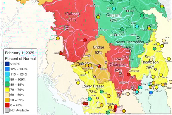
The Lower Thompson region — which includes Lytton, Ashcroft, Cache Creek, Clinton, and Merritt — was sitting at 42 per cent of normal as of Feb. 1; a significant drop from Jan. 1, when it was at 133 per cent of normal.
The Lower Thompson is one of four areas comprising the Middle Fraser region, which was at 64 per cent of normal; a drop from 88 per cent on Jan. 1. The Chilcotin region, for which no January figures were available, was at 31 per cent of normal on Feb. 1, while the South Thompson region, which includes Kamloops, was at 78 per cent; a drop from Jan. 1, when it was at 100 per cent of normal.
The 72 per cent figure for the entire province is an improvement on the Feb. 1, 2024 figure, when the provincial average was 61 per cent. The report notes that by early February, approximately two-thirds of the annual B.C. snowpack has typically accumulated, but that there are still two or three months left in the snow accumulation season.
While temperatures were near normal in January throughout most of the province, precipitation in most areas was well below normal, with a two-week period from mid- to late-January with extremely dry conditions. Most regions of the province were within the top 10 driest years for January over their respective periods of record, with several measuring in their top five driest Januarys, including Penticton (records have been kept since 1908), Kelowna (1900), and Vernon (1901).
The report adds that a widespread moderate precipitation event over the southern half of the province in the last two days of January prevented several locations from reaching new record lows for January precipitation.
Environment and Climate Change Canada is forecasting a greater likelihood of below normal temperatures for most of B.C. from February through April. Precipitation is more difficult to predict, but there is a greater likelihood of above normal precipitation for the same period throughout the Southern Interior.
Seasonal volume runoff forecasts are near normal (80 to 105 per cent of normal) for the Upper Fraser, Quesnel River, North and South Thompson Rivers, and the Thompson River. With below normal snowpack across most regions, seasonal flood hazards are expected to be reduced this season. However, extreme rainfall and rain-on-snow during the freshet period remains a hazard, regardless of snowpack levels. The April 1 snow survey results are the benchmark for understanding upcoming seasonal flood hazards with more certainty.
The snow Survey and Water Supply Bulletin is conducted by the province’s Ministry of Water, Land and Resource Stewardship and uses data from 40 manual snow courses and 113 automated snow weather services around B.C. The next report is due out on or about March 10.


