B.C. boasts many ghost—and near-ghost—towns, most of which boomed during the initial exploitation of natural resources in the province beginning in 1858, when gold was discovered on the Fraser and Thompson rivers and then in the goldfields of the north. Gold, minerals, coal, trees: all were dug up or cut down, bringing booming prosperity to many towns for a short time.
When the resources were exhausted, however, many of the towns built around them withered and died, as the inhabitants moved elsewhere, leaving only crumbling husks of buildings behind them to mark their brief stay. Ghost towns abound around the province; but few of them have the romance, allure, and tragedy of Walhachin, on the banks of the Thompson River.
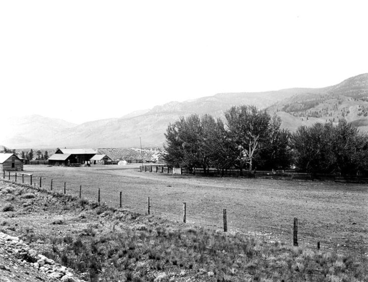
It is not quite correct to call it a ghost town, as several dozen people still live there, and the Soldiers Memorial Hall there has recently been renovated to make it a thriving community hub. However, a look at the town’s past shows what once was there, and what might have been, had not Fate intervened.
The man behind the venture at Walhachin was an American named Charles E. Barnes, who in 1907 was working as a land surveyor based in Ashcroft (and was no relation to Ashcroft founding father John Barnes). He had visited the ranch of Charles Pennie, on the south side of the Thompson River some 15 miles east of where Barnes was working, and been impressed by the two-acre orchard the rancher had established near his ranch house.
Across Canada, and especially in B.C., there was much talk at the time about orchards, which were seen as a renewable resource, and much less risky than panning or mining for gold. When Barnes began talking about developing the whole valley near Pennie’s ranch into an orchard, he was not met with derision; instead, people listened.
Barnes was a newcomer to the area, and did not realize that small orchards were common on ranches and farmsteads, and did not necessarily indicate that the entire area was suitable for orchards. This was particularly true in the case of Pennie’s orchard, the site of which had been chosen with great care. It was planted on particularly arable, rock-free land, in a spot close to one of the few creeks in the area, and where higher ground around it provided the trees with some shelter from the often fierce winds that swept the valley.
But Barnes did not know this. What he did know was that that he needed financial backing, and settlers who would be willing to work to make his vision a reality. So he approached the British Columbia Development Association (BCDA), which had been founded in 1895 and was based in England. The BCDA had already invested in projects in B.C., including the 2,000- acre 111 Mile Ranch; so Barnes invited Sir William Bass, one of the leading directors of the BCDA, to travel to B.C. and see the site. Bass was accompanied by two other men: Palmer, a qualified agriculturist, and Ashcroft, a qualified engineer.
Palmer and Ashcroft were disposed to look favourably at the plan for what became Walhachin, as they were employed on the English estate of John Campbell Gordon, the 7th Earl of Aberdeen, who was a keen orchardist. An orchard that Gordon had established near Vernon in 1891 had been a great success, and one must assume that the two Englishmen—not well-versed in the geography of British Columbia—assumed that what was successful near Vernon would be equally successful near Cache Creek.
In reaching this conclusion, the men overlooked the sandy soil of the area, the abundance of rocks, the absence of adequate and near-by irrigation, and the harsh climate conditions. They whole-heartedly endorsed Barnes’s proposal, and Bass recommended to the BCDA that it should purchase the Pennie ranch and develop an orchard settlement on the banks of the Thompson River.
The Pennie Ranch and an adjacent property of 930 acres were purchased in January 1908, with an additional 3,265 acres on the north bank of the Thompson purchased shortly thereafter. The business of promoting the area, and drawing settlers, then began; and one of the first things considered was the site’s name.
The area that had been bought up included a railway station, which was called Pennie’s after the family which had owned the property, but the founders had a grand vision: not just an orchard, but a complete modern town, with all the amenities that demanded. For that they needed settlers, as well as investors, and Pennie’s would not do; the town demanded a less prosaic and more appealing name.
“Walhassen” was what they chose, which was the Nlaka’pamux (Thompson) name for the site; and advertising literature for the new town chose to translate this as “bountiful valley”. However, the true meaning of the word (according to the Nlaka’pamux people themselves), was actually “land of round rocks”.
Anyone who knows the uncultivated state of the landscape around Walhachin will agree that “land of round rocks” is a perfectly apt description of it; certainly a more apt description than “bountiful valley”. It is difficult to believe that the people advertising the community would purposely make such a mistake, although the cynical amongst us might suggest that the confusion was deliberate, meant to deceive would-be settlers and investors into thinking the prospect of an orchard community at Walhachin was a more certain prospect than it actually was.
Be that as it may, the town’s name was changed, in 1909, to the very similar-sounding “Walhachin”. A subsequent advertising brochure stated that this name was “an Indian word signifying an abundance of food products of the earth” (which sounds like “bountiful valley” as interpreted by someone getting paid by the word). The Nlaka’pamux people have thus far remained silent regarding the truth (or not) of this interpretation of their name for the site.
To be continued


