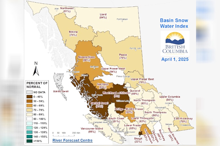
The April 1 snow survey for British Columbia shows that the provincial snowpack is still below normal, averaging 79 per cent of normal across the province.
This is up from the March 1 survey, which showed an average provincial snowpack of 73 per cent of normal, and from the same point a year ago, when the snowpack stood at 63 per cent of normal for the province. The survey notes that by April 1, approximately 96 per cent of B.C.’s seasonal snowpack has typically accumulated.
Because of this, a below normal spring freshet hazard is expected due to low snowpack. However, the flip side is that the low snowpack and seasonal runoff, combined with warm seasonal weather forecasts and lingering impacts from ongoing drought, are pointing the way towards elevated drought hazards this spring and summer.
The April 1 survey was the province’s fourth Snow Survey and Water Supply Bulletin of the year, and was released on April 9. No region in B.C. was at or above the normal snowpack level as of April 1; the only regions to come close were the Boundary region (98 per cent) and the Upper Fraser West region (94 per cent).
The Lower Thompson region — which includes Lytton, Ashcroft, Cache Creek, Clinton, and Merritt — had been sitting at 133 per cent of normal as of March 1, but by April 1 had dropped to 83 per cent.
The Lower Thompson is one of four areas comprising the Middle Fraser region, which was at 75 per cent of normal on April 1 (up from 66 per cent of normal). The South Thompson region, which includes Kamloops, was at 86 per cent, up from 78 per cent on March 1.
Temperatures in March ranged from normal to above normal throughout B.C. Precipitation varied considerably, with areas of the Southern Interior seeing near record-high March precipitation totals, while many areas in the north where considerably drier than normal. Environment and Climate Change Canada is forecasting a greater likelihood of above normal temperatures for most of B.C. from April through June.
Seasonal volume runoff forecasts are near normal (85 to 115 per cent of normal) for the Upper Fraser, Quesnel River, North and South Thompson Rivers, and the Thompson River. With below normal snowpack across most regions, seasonal flood hazards are expected to be reduced this season. However, the April survey notes that “Snowmelt related flooding can still occur for areas with slightly below normal snowpack levels if adverse weather patterns, in particular, heavy rainfall or high-pressure ridges, emerge this spring. . .
“It is important to note that May and June are wet months through the B.C. Interior with the potential for extreme precipitation patterns. . . Therefore, precipitation poses a flood risk through the spring even with limited snowpack.”
The Snow Survey and Water Supply Bulletin is conducted by the province’s Ministry of Water, Land and Resource Stewardship and uses data from 40 manual snow courses and 113 automated snow weather services around B.C. The next report is due out on or about May 8.


