There’s more than meets the eye to a geological peculiarity popular with hikers and mountain bikers behind Nanaimo.
Anyone who’s hiked or biked the Extension Ridge Trail will have stumbled upon – or into if not given fair warning – the Abyss. The long, deep crack can be found in otherwise solid sandstone conglomerate bedrock rising about 80 metres above the surrounding landscape to form the Extension Ridge that spans roughly five kilometres from Harewood Mines Road in Nanaimo to Virostko Road in Extension. Extension Ridge Trail is actually a section of the Trans-Canada Trail network.
The trail head to the Abyss is located where the B.C. Hydro power lines cross Harewood Mines Road. The trail is a moderately easy hike that offers beautiful views of Nanaimo, the Salish Sea and the Coast Mountains, but hikers should tread carefully, especially in the wet fall and winter months, when rain and ice makes exposed roots and rock surfaces slippery. For their safety, keep dogs on a leash – several have tumbled into the Abyss in recent years, although none have been lost, thanks to Nanaimo Fire Rescue firefighters who’ve risked their safety to retrieve the pets and reunite them with their owners.
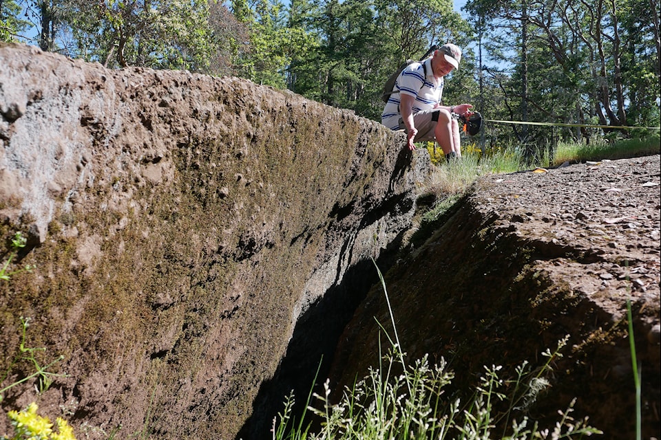
The Abyss presents as a fissure about 40 metres long, about half a metre wide and at least eight metres deep, but Tim Stokes, a professor with Vancouver Island University’s Earth sciences department, describes some interesting geology underlying the fractured rock. As to how and when the Abyss came to be, all Stokes can accurately say is, “it depends.”
Extension Ridge is one of a series of ridges behind Nanaimo which share similar characteristics of a gentle slope on their north sides, steep bluffs on their south faces and huge stone blocks that form as fragments from erosion and tumble down to the land below. Strangely, some blocks remain perched atop the ridges near the upper edges of their bluffs.
“A lot of them actually have fractures that parallel the edge of the ridge, but none, maybe, as open and as long as the Abyss and not so pronounced," Stokes said.
The age of the conglomerate bedrock itself formed 65-90 million years ago, but when and how the crack appeared hasn’t been determined.
“It’s got some unique things about it,” the professor said. “It’s got a really sharp edge, which would suggest to me, geologically, it’s pretty recent. In the last thousands of years.”
Long parallel scratches, called striations, across the rock surface were caused during the ice ages when giant glaciers scraped rocks across the bedrock. Some will date from about 10,000 years ago during the last ice age. Petroglyphs carved in the ridge's stone face may date to the time of the first post-ice age inhabitants after the glaciers receded.
“Glaciation has probably played a big part in sculpting the ridges and eroding the material between the ridges away,” Stokes said. “When you look at the shape of Vancouver Island we think a lot of the glaciers came along the same direction and that’s pretty much parallel to these ridges, so there’s a connection, I think, between the direction the glaciers move and the way the ridges are.”
But other forces were likely involved. The bedrock layers that were once horizontal were likely tilted by tectonic forces to the angle visitors see today, but sheer mass of kilometre-thick glaciers was a possible contributor. When the ice receded and its weight lifted, the land was able to spring up – a process called isostatic rebound. As the bedrock rose it may have fractured at weak points, creating features like the Abyss.
Coal mining under the ridge could have also contributed. There are the remains of at least one old coal mine and exploratory digs by prospectors in Extension Ridge. The former Harewood Mine – according to information compiled by VIU on historic Nanaimo coal mines – produced more than 750,000 tonnes of coal between 1874 and 1951 under various owners who intermittently started and halted operations as ownership changed hands. Unlike other mines with vertical shafts leading to coal seams, some of which were well below sea level, the Harewood Mine was above sea level and had a shaft that extended horizontally into the side of Extension Ridge, so miners could simply walk in to access the mine.
Stokes said he also wouldn't discount the idea that the Abyss might have been created by an earth tremor. The last megathrust earthquake that impacted the Island happened in 1700, and the professor said the ridges would have experienced a lot of vibration.
“So I think the ridges formed, obviously, by tectonic forces and then why rocks seem to tumble off is going to be related to the story, whether it’s glaciation, whether it’s isostatic rebound, whether it’s undermining of the coal seams or whether it’s just weathering and toppling over time,” Stokes said. “So, it depends.”
View the 101 Things to See and Do in Nanaimo e-edition at this link.

